Tourist Places
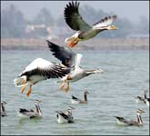
One of Odisha's major attractions is its 500 km long coastline and beaches and natural scenery such as Chilka Lake, Asia's largest brackish water lake. There is an important bird sanctuary for millions of birds, and is also noted for its population of Irrawaddy Dolphin (Orcaella brevirostris), the only known population of Irrawaddy dolphins in India. It is one of only two lagoons in the world that are home to this species.
- Chilika Lake
- Khandagiri & Udayagiri
- Dhauligiri
- Paradip Port
- Ratnagiri
- Saptasajya
- Khandadhar
- Ghagara
- Daringbadi
- Kolab Dam
- Duduma Waterfall
- Hirakud Dam
Chilika Lake, Chilika
 Chilka Lake - Asia's largest brackish
water lagoon with water spread ranging from 1165 sq km m the rainy season to 906 sq km in the
dry season is nestled in the heart of the coastal Odisha (Orissa). It extends from Bhusandpur in
Puri district in the North to Rambha-Malud in Ganjan district in the South, separated from the
Bay of Bengal by a 60 km long narrow strip of marshy islands and sand-flats.
Chilka Lake - Asia's largest brackish
water lagoon with water spread ranging from 1165 sq km m the rainy season to 906 sq km in the
dry season is nestled in the heart of the coastal Odisha (Orissa). It extends from Bhusandpur in
Puri district in the North to Rambha-Malud in Ganjan district in the South, separated from the
Bay of Bengal by a 60 km long narrow strip of marshy islands and sand-flats.
Chilika is recognized as one of the most important wetlands in the world because it is home to a phenomenal variety of birds. Chilika Lake offers visitors a spectacular display of its colorful avian charms in a thousand different hues presented by over 160 species in the peak season between November and February. The lake and its reed islands teem with nesting birds-white bellied sea eagles, ospreys, golden plovers, sand pipers, flamingos, pelicans, shovellers, gulls, include migratory ones flying great distances from Iran, Central Asia and Siberia.
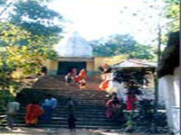
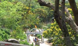
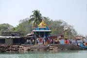 Kalijai Temple :-
Located on an island in the Chilika Lake, Kalijai Temple is one of the famous attractions. The
temple worships Goddess Kalijai. The deity is highly revered among the locals as well as in
their folklores and fables. The island is also a mesmerizing destination for pilgrims as well as
tourists and can be reached via a boat from Chilika Lake. Makar Sankranti is celebrated with
great pomp and cheer at the temple that attracts numerous travelers & devotees.
Kalijai Temple :-
Located on an island in the Chilika Lake, Kalijai Temple is one of the famous attractions. The
temple worships Goddess Kalijai. The deity is highly revered among the locals as well as in
their folklores and fables. The island is also a mesmerizing destination for pilgrims as well as
tourists and can be reached via a boat from Chilika Lake. Makar Sankranti is celebrated with
great pomp and cheer at the temple that attracts numerous travelers & devotees.
Satapada village, at the new mouth of the lake, provides a beautiful view of the Lake and also views of the Dolphins. Hundreds of boats here provide tours of the lake for tourists.
Birds' island, located in the southern sector of the lake has huge exposed hanging rocks, are painted white due to folic acid of the droppings of the birds and is known for rich algal communities and few mangrove species and also migratory birds in winter.
The Breakfast Island, pear shaped, known as "Sankuda island", with remnants of a dilapidated bungalow constructed by the King of Khallikote, has rare plants and is full of greenery with appealing flora.
Honeymoon Island, 5 km (3.1 mi) from Rambha Jetty, known as Barkuda Island, with clear waters has abundant red and green macro algae in the bed is also known for the limbless lizard, an endemic species found here.
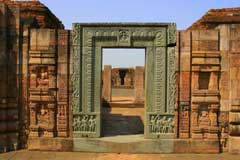
Khandagiri & Udayagiri, Bhubaneswar
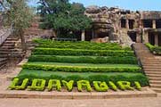 Udayagiri and Khandagiri Caves are partly
natural and partly artificial caves of archaeological, historical and religious importance near
the city of Bhubaneswar in Orissa, India. The caves are situated on two hills Udayagiri and
Khandagiri, mentioned as Kumari Parvat in Hathigumpha inscription and face each other across the
road.
Udayagiri and Khandagiri Caves are partly
natural and partly artificial caves of archaeological, historical and religious importance near
the city of Bhubaneswar in Orissa, India. The caves are situated on two hills Udayagiri and
Khandagiri, mentioned as Kumari Parvat in Hathigumpha inscription and face each other across the
road.
They have a number of finely and ornately carved caves. It is believed that most of these caves were carved out huge residential blocks for the Jain monks, during the reign of King Kharavela. Udayagiri meaning Sunrise Hill, has 18 caves while Khandagiri has 15 caves.
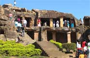 The caves of Udayagiri and Khandagiri, called
lena or leṇa in the inscriptions, were dug out mostly during the reign of Kharavela for the
abode of Jaina ascetics. The most important of this group is Ranigumpha in Udayagiri which is a
double storeyed monastery. Unfortunately, a number of the Jaina caves on the Khandagiri side
have encroachment problems, with local Brahmins turning them into Hindu shrines and covering up
some of the Jaina iconography.
The caves of Udayagiri and Khandagiri, called
lena or leṇa in the inscriptions, were dug out mostly during the reign of Kharavela for the
abode of Jaina ascetics. The most important of this group is Ranigumpha in Udayagiri which is a
double storeyed monastery. Unfortunately, a number of the Jaina caves on the Khandagiri side
have encroachment problems, with local Brahmins turning them into Hindu shrines and covering up
some of the Jaina iconography.
Dhauligiri, Bhubaneswar
 Dhauligiri Hills is a place marked with the
serenity of Daya River and lies at a distance of 8 Km from Bhubaneswar. The famous rock edicts
of Ashoka are worth witnessing. Moreover, it is in Dhauli Hills that adopted the path of dharma
which lets only peace and love enter your lives. The concept of dharma- vijay became his
ultimate goal as he took Buddhist teachings deep into his heart. The end of the bloody battles
was only to serve and favor mankind. With this, the religious and spiritual beliefs of Buddhism
spread to different parts of the world. Dhauli Hills in Bhubaneswar takes you to the site of the
Vishwa Shanti Stupa. The dome structure of the Shanti Stupa possesses five umbrellas and they
symbolize the five essential parts of Buddhism.
Dhauligiri Hills is a place marked with the
serenity of Daya River and lies at a distance of 8 Km from Bhubaneswar. The famous rock edicts
of Ashoka are worth witnessing. Moreover, it is in Dhauli Hills that adopted the path of dharma
which lets only peace and love enter your lives. The concept of dharma- vijay became his
ultimate goal as he took Buddhist teachings deep into his heart. The end of the bloody battles
was only to serve and favor mankind. With this, the religious and spiritual beliefs of Buddhism
spread to different parts of the world. Dhauli Hills in Bhubaneswar takes you to the site of the
Vishwa Shanti Stupa. The dome structure of the Shanti Stupa possesses five umbrellas and they
symbolize the five essential parts of Buddhism.
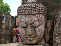
Dhauli is an amazing place for going for excursions. Lying at a distance of 8 Km from Bhubnaeswar, the charm of this place gets ameliorated through the sight of primitive sculptors and varied art forms. Close to the pagoda, one can spot the beautiful Saddahrma Vihar Monastery as well as the Shanti Stupa. The stupa was constructed by the Buddha Sangha. One can also spot enthralling Ashokan edicts that add to the significance of Buddhism to this place. Varied excursions can be enjoyed by visiting the Dhauli pilgrimage.
Dhauli is famous for the edicts related to Buddhism that were composed from the Brahmi script and used Prakrit language. One can spot a series of rock cut monuments at this hill. Numerous artifacts tell us about the urban settlement at this place in the 3rd century B.C. One finds the image of intricately carved elephant and close to this elephant, you have a stupa.
Moreover, Dhauli also has another attraction named as the Shanti Stupa whose foundation was laid by the Japan Buddhist Sangha. Therefore, Dhauli is a worth visiting place by the diehard devotees of Lord Buddha.
Paradip Port, Jagatsinghpur
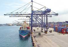 Paradip Port is an artificial, deep-water
port on the East coast of India in Jagatsinghpur district of Odisha. It is situated at
confluence of the Mahanadi river and the Bay of Bengal. It is situated 210 nautical miles south
of Kolkata and 260 nautical miles north of Visakhapatnam. The port is administered by the
Paradip Port Trust (PPT), an autonomous corporation wholly owned by the Government of India.
Paradip Port is an artificial, deep-water
port on the East coast of India in Jagatsinghpur district of Odisha. It is situated at
confluence of the Mahanadi river and the Bay of Bengal. It is situated 210 nautical miles south
of Kolkata and 260 nautical miles north of Visakhapatnam. The port is administered by the
Paradip Port Trust (PPT), an autonomous corporation wholly owned by the Government of India.
Paradip Port is one of the Major Ports of India serving the Eastern and Central parts of the country. Its hinterland extends to the States of Odisha, Jharkhand, Chhattisgarh, West Bengal, Madhya Pradesh and Bihar. The Port mainly deals with bulk cargo apart from other clean cargoes. There is unprecedented growth in the traffic handled at this Port in the last decade. The Port has got ambitious expansion programme to double its capacity to meet the ever increasing demand.
 Government of India took over the
management of the Port from the Government of Orissa on 1st June 1965. INS "INVESTIGATOR" had
the privilege of maiden berthing in the Port on the 12th March, 1966. The Port was declared open
by Mr. Peter Stambolic, Prime Minister of Yugoslavia on the same day. Government of India
declared Paradip as the Eighth Major Port of India on 18th April 1966 making it the FIRST MAJOR
PORT in the East Coast commissioned after independence. The Port of Paradip, an autonomous body
under the Major Port Trusts Act, 1963 functioning under Ministry of Shipping is administered by
a Board of Trustees set up by the Government of India headed by the Chairman, PPT. The trustees
are nominated by Government of India from various users of the Port such as shippers, ship
owners; Government Departments concerned and also port labour. The day - to - day administration
is carried out under general supervision and control of the Chairman, assisted by the Deputy
Chairman and other departmental heads.
Government of India took over the
management of the Port from the Government of Orissa on 1st June 1965. INS "INVESTIGATOR" had
the privilege of maiden berthing in the Port on the 12th March, 1966. The Port was declared open
by Mr. Peter Stambolic, Prime Minister of Yugoslavia on the same day. Government of India
declared Paradip as the Eighth Major Port of India on 18th April 1966 making it the FIRST MAJOR
PORT in the East Coast commissioned after independence. The Port of Paradip, an autonomous body
under the Major Port Trusts Act, 1963 functioning under Ministry of Shipping is administered by
a Board of Trustees set up by the Government of India headed by the Chairman, PPT. The trustees
are nominated by Government of India from various users of the Port such as shippers, ship
owners; Government Departments concerned and also port labour. The day - to - day administration
is carried out under general supervision and control of the Chairman, assisted by the Deputy
Chairman and other departmental heads.
Ratnagiri, Jajpur
 Ratnagiri was once the site of a mahavihara, or
major Buddhist monastery, in the Brahmani and Birupa river valley in Jajpur district of Orissa,
India. It was part of the Puspagiri University, together with Lalitgiri and Udayagiri.
Ratnagiri was once the site of a mahavihara, or
major Buddhist monastery, in the Brahmani and Birupa river valley in Jajpur district of Orissa,
India. It was part of the Puspagiri University, together with Lalitgiri and Udayagiri.
History :- Ratnagiri was established no later than the reign of the Gupta king
Narasimha Baladitya in the first half of the sixth century CE, and flourished until the twelfth
century CE. A Tibetan history, the Pag Sam Jon Zang, identifies Ratnagiri as an important center
in the development of the Kalachakratantra in the 10th century CE, an assertion supported by the
discovery of a number of votive stupas, plaques, and other artifacts featuring Kalachakra
imagery.
 According to Amit Jha, a lecturer in the
Department of History at Sri Aurobindo College, Delhi University, "Ratnagiri comprises two
magnificent monasteries, also rebuilt more than once. One of them was double-storyed and had an
extensive courtyard with two-sides of it having a number of cells for habitation of monks.
Besides, we have archaeological remains of six temples, thousands of small stupas, 1386 seals,
myriad sculptural relics and architectural pieces of daily use. The largest stupa was 47 feet
(14 m) square and 17 feet (5.2 m) high surrounded by four minor stupas. There are hundreds of
miniature votive stupas decorated with lotus, petal and beaded tassels." A museum now located on
the site displays statuary featuring Tara, Avalokiteshvara, Aparajita, and Hariti have also been
found, all in prototypical of Gupta style.
According to Amit Jha, a lecturer in the
Department of History at Sri Aurobindo College, Delhi University, "Ratnagiri comprises two
magnificent monasteries, also rebuilt more than once. One of them was double-storyed and had an
extensive courtyard with two-sides of it having a number of cells for habitation of monks.
Besides, we have archaeological remains of six temples, thousands of small stupas, 1386 seals,
myriad sculptural relics and architectural pieces of daily use. The largest stupa was 47 feet
(14 m) square and 17 feet (5.2 m) high surrounded by four minor stupas. There are hundreds of
miniature votive stupas decorated with lotus, petal and beaded tassels." A museum now located on
the site displays statuary featuring Tara, Avalokiteshvara, Aparajita, and Hariti have also been
found, all in prototypical of Gupta style.
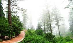
Saptasajya, Dhenkanal
 A place of scenic beauty, Saptasajya is
situated at a distance of 11 kms from Dhenkanal. The place is ideal for picnic and relaxation.
As legends would have it, the Pandavas spent some days of their incognito life in these hills.
The Saptarishi temple and the temple of Raghunath attract a large number of persons on the
Ramnavami day which falls in March-April. A small spring flowing close by enhances the beauty of
the place.
A place of scenic beauty, Saptasajya is
situated at a distance of 11 kms from Dhenkanal. The place is ideal for picnic and relaxation.
As legends would have it, the Pandavas spent some days of their incognito life in these hills.
The Saptarishi temple and the temple of Raghunath attract a large number of persons on the
Ramnavami day which falls in March-April. A small spring flowing close by enhances the beauty of
the place.
One can proceed 12 km in the Sankarpur road from Dhenkanal Bus stop and then turn west at the Badagila chowk and pass two km to reach Saptya Sajya a scenic beauty where the holy temple of Maryada Purusottama Sri Ramachandra is located at about 900 feet at the hilltop. A mountains stream flows down as if touching his holly feet in veneration. Mythologically this place is important and many legends are still available. Its name is Sapta Sajya because, there are seven hills surrounding the area. Again there is story that, the Saptarashi had their ashramas here in this place.
 There is also a mythological story, that,
Sriram during his exiled or Vanabasha had spent seven days in this beautiful spot. Secondly the
Pandavas during their 12 years of exile and one year of Agyanta Vasa had chosen this mountains
for shelter. The Govt. constructed the Pukka road way in 1982. Inside the temple complex Maa
Annapurna temple was constructed in 1982, the 1st floor Kalki temple in 1985, the Surya Narayan
temple in 1990. Now the temple of Sri Rameswaram Shiva, Sri Ganesh, Sri Mahavir, and the
Nabagrah Temple with each room for each graha are found. Mahakali, Mata Saraswati, Sri
Nrushingha temple are conceived to be built in the holy complex. This scenic spot has become a
good tourist and picnic spot where thousands of tourists and devotees gather from different
corners of Odisha and India.
There is also a mythological story, that,
Sriram during his exiled or Vanabasha had spent seven days in this beautiful spot. Secondly the
Pandavas during their 12 years of exile and one year of Agyanta Vasa had chosen this mountains
for shelter. The Govt. constructed the Pukka road way in 1982. Inside the temple complex Maa
Annapurna temple was constructed in 1982, the 1st floor Kalki temple in 1985, the Surya Narayan
temple in 1990. Now the temple of Sri Rameswaram Shiva, Sri Ganesh, Sri Mahavir, and the
Nabagrah Temple with each room for each graha are found. Mahakali, Mata Saraswati, Sri
Nrushingha temple are conceived to be built in the holy complex. This scenic spot has become a
good tourist and picnic spot where thousands of tourists and devotees gather from different
corners of Odisha and India.
Khandadhar Waterfalls, Sundergarh
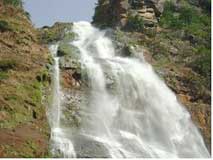 The Khandadhar Falls is located at Nandapani
in Sundergarh district in the Indian state of Odisha. It is the 12th highest waterfall in India.
It is a perennial horse tail type waterfall. The Korapani Nala, a small stream, plunges from a
height of 244 metres (801 ft) in a single drop.
The Khandadhar Falls is located at Nandapani
in Sundergarh district in the Indian state of Odisha. It is the 12th highest waterfall in India.
It is a perennial horse tail type waterfall. The Korapani Nala, a small stream, plunges from a
height of 244 metres (801 ft) in a single drop.
There is an interesting legend amongst the Pauri Bhuiya tribals who inhabit the area around Khandadhar. The legend is reproduced from Outlook.
“A Pauri Bhuiya legend speaks of how their mountains came to be so munificent. The Sundergarh branch of the community was once possessed by a rapacious goddess named Kankala Devi, who consumed trees, soil and everything else. In despair, the Pauri Bhuiya placed her on a rock, which she ate through as well—creating a deep hole from which poured out the Khandadhara (split-rock waterfall). So they had water. Then a couple from the community went to visit relatives at the eastern, or Keonjhar, end of the Khandadhar mountain range. Their prospective hosts were away but a pile of grains had been left outdoors and, amazingly, not even the birds were eating it. Inside the heap, the couple discovered a small goddess, Khand Kumari, protector of the region’s prosperity. They stole her and brought her back to Sundergarh, and so her bounty became theirs.
Sanaghagara & Badaghagara Waterfall, Keonjhar
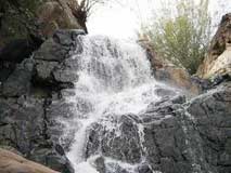 Sanaghagara Waterfall :- The
Sanaghagara Waterfall is a beautiful waterfall of the Kendujhar district in the Indian state of
Orissa. It is a perennial waterfall. The Machha Kandana, a small river, plunges from a height of
30.5 metres (100 ft) in two drops. It is a small (100 ft. high) and beautiful waterfall,
suitable for outing. The area is spread over 488 Ha. In a hilly tract with characteristic mixed
deciduous and miscellaneous type of forest vegetation.
Sanaghagara Waterfall :- The
Sanaghagara Waterfall is a beautiful waterfall of the Kendujhar district in the Indian state of
Orissa. It is a perennial waterfall. The Machha Kandana, a small river, plunges from a height of
30.5 metres (100 ft) in two drops. It is a small (100 ft. high) and beautiful waterfall,
suitable for outing. The area is spread over 488 Ha. In a hilly tract with characteristic mixed
deciduous and miscellaneous type of forest vegetation.
Sanaghagara is located at a distance of 6 km from the district headquarters (Kendujhar) of Kendujhar district. It is situated at a distance of 3 kilometers on the upstream of Badaghagara Waterfall.
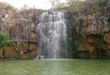 Badaghagara Waterfall :-
Badaghagra falls in Orissa are an important tourist destination. Flowing at a distance of 10 kms
from Keonjhar and 196 kms from Rourkela, this waterfall is popular for its serene and calm
ambiance. Falling from a height of 60 mts or 200 feets, river Ghaghra is the source of this
waterfall.
Badaghagara Waterfall :-
Badaghagra falls in Orissa are an important tourist destination. Flowing at a distance of 10 kms
from Keonjhar and 196 kms from Rourkela, this waterfall is popular for its serene and calm
ambiance. Falling from a height of 60 mts or 200 feets, river Ghaghra is the source of this
waterfall.
This popular picnic spot invites tourist to enjoy some unruffled time amidst the nature. Trekking here is another great option. The jagged topography of the area invites nature lovers, picnickers and hikers alike.
Daringbadi, Kandhamal
 Daringbadi,a Plateu and a beautiful
area.The height is 3000ft above sea level. It is an ideal summer resort which is popularly known
as Kashmir of Odisha or the heaven of odisha. This place is gifted with natural scenery like
pine trees, coffee gardens and beautiful valleys.
Daringbadi,a Plateu and a beautiful
area.The height is 3000ft above sea level. It is an ideal summer resort which is popularly known
as Kashmir of Odisha or the heaven of odisha. This place is gifted with natural scenery like
pine trees, coffee gardens and beautiful valleys.
It is the only place in Orissa which experiences snow fall during Winter season. Journy to the hills of Daringbadi is an experience in itself. This pretty hill station is hundred kilometres from Phulbani and fifty kilometres from Balliguda.
 The resting places are P.W.D. Inspection
Bunglow. It is near from the capital of odisha.The tourists will visit this place easity with
their own vehicles,bus,train,and also aeroplane.The journey from the plains to the hills of
Daringbadi is an experience in itself.
The resting places are P.W.D. Inspection
Bunglow. It is near from the capital of odisha.The tourists will visit this place easity with
their own vehicles,bus,train,and also aeroplane.The journey from the plains to the hills of
Daringbadi is an experience in itself.
There are two Coffee & black pepper plantations maintained by siol conservation/forest department daringbadi area which are an ideal place to explore and picnic.
Kolab Dam, Koraput
 At an altitude of about 3000 ft. above sea
level on river Kolab, stands the majestic Kolab Reservoir generating Hydro Electric Power.15 km
from Koraput, the river Kolab makes a spectacular jump at Bagra to form a reservoir called the
“Upper Kolab Irrigation Project”. An ideal place for an outing, it is also a panacea for city
dwellers.
At an altitude of about 3000 ft. above sea
level on river Kolab, stands the majestic Kolab Reservoir generating Hydro Electric Power.15 km
from Koraput, the river Kolab makes a spectacular jump at Bagra to form a reservoir called the
“Upper Kolab Irrigation Project”. An ideal place for an outing, it is also a panacea for city
dwellers.
Kolab Botanical Garden stands beside the Majestic Kolab reservoir is ideal for weekend picnic for people all over the district. This place is highly admired for its scenic beauty, attracting tourists for weekend picnic and boating. Kolab Botanical Garden stands beside the Majestic Kolab reservoir is ideal for weekend picnic for people all over the district.
 This place is highly admired for its scenic
beauty, attracting tourists for weekend picnic and boating. The well maintained botanical garden
has over 200 varieties of flowering plants. Even the night view of the reservoir is worth
experiencing.
This place is highly admired for its scenic
beauty, attracting tourists for weekend picnic and boating. The well maintained botanical garden
has over 200 varieties of flowering plants. Even the night view of the reservoir is worth
experiencing.
At one end of the Jeypore town there is a water reserve which stores water coming out of the power generation unit of upper Kolab Dam. This water reserve is a favorite area for morning walkers. To feed this 4 x 80 MW power station there is a huge water reserve at the top of the hill known as Upper Kolab Dam. After travelling 10 KM from Jaypore town towards Koraput there is a right turn and from here the water reserve is 8 KM. After taking right turn from main road travel 2 KM and then take right turn. Further 2 KM from here take left turn and dam will be at 3 KM from here. ( total 8 KM from main road ). Boating facility is available here. There is an entry fee of Rs 10 per person, Kids from 5 to 12 year is Rs 5. Two wheeler entry fee is Rs 5 , four wheeler / LMV is Rs 10 bus and heavy vehicles are charged Rs 50/-. The entry is open from 9 AM to 7.30 PM all the days.
Duduma Waterfall, Machkund
 The Duduma Waterfall, 175 metres (574 ft) high,
is formed by the Machkund river in Odisha, India. Duduma is about 92 km from Koraput and about
200 km from Visakhapatnam. It forms a part of the boundary between Andhra Pradesh and Odisha.
The Duduma Waterfall, 175 metres (574 ft) high,
is formed by the Machkund river in Odisha, India. Duduma is about 92 km from Koraput and about
200 km from Visakhapatnam. It forms a part of the boundary between Andhra Pradesh and Odisha.
Duduma Waterfalls is one of the highest waterfalls in Southern India. Its waters support a large hydroelectric project called Machkund Hydro Electric Power Project. Machkund is an important place for pilgrimage. The name Machkund derived from a piligrimage point called 'Matsya Kunda'near the township of Paderu in Andhra Pradesh. A beautiful township called 'Onukudelli' has grown around this lovely place. The aboriginal tribe of 'Bondas' live near this waterfalls. It has two sub-waterfalls one on the Odisha side and the other on the Andhra Pradesh side. The waterfalls lie in picturesque surroundings. It is one of the best tourist spots in Southern India.
Investigation and research on the Dumduma Falls began in the year 1941 when the plan for generating hydro-electric power was chalked out. It was around the year 1946, that the scheme was implemented. 104cfs are drawn from the Dumduma hydro electrical plant which hints at the fact that that this waterfall in Orissa is still very active.
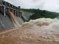
Hirakud Dam, Sambalpur
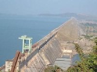 Hirakud Dam built on Mahanadi River is the
longest dam in India. The overall length of the main dam is 4.8 km, and the total length is
25.8km with dam and dykes taken together. The dam is about 15 km upstream of Sambalpur town in
State of Orissa and was the first post independence major multipurpose river valley project in
India. The dam irrigates 436000 ha of CCA in Mahanadi delta and has an installed capacity of
307.5 MW. Hirakud Dam is a composite structure of Earth, Concrete and Masonry. Hirakud Dam
intercepts 83400 sq. km (32200 sq miles) of Mahanadi catchments. It has a reservoir spread of
743 sq km at full reservoir level and the reservoir has a storage of 5818 M. Cum with gross of
8136 M Cum.
Hirakud Dam built on Mahanadi River is the
longest dam in India. The overall length of the main dam is 4.8 km, and the total length is
25.8km with dam and dykes taken together. The dam is about 15 km upstream of Sambalpur town in
State of Orissa and was the first post independence major multipurpose river valley project in
India. The dam irrigates 436000 ha of CCA in Mahanadi delta and has an installed capacity of
307.5 MW. Hirakud Dam is a composite structure of Earth, Concrete and Masonry. Hirakud Dam
intercepts 83400 sq. km (32200 sq miles) of Mahanadi catchments. It has a reservoir spread of
743 sq km at full reservoir level and the reservoir has a storage of 5818 M. Cum with gross of
8136 M Cum.
Hirakud Dam is built across the Mahanadi River, about 15 km from Sambalpur in the state of Orissa in India. Built in 1956, the dam is the worlds largest earthen dam.[1] Behind the dam extends a lake, Hirakud Reservoir, 55 km long. Hirakud Dam is one of the longest dams in the world, about 16 mi (26 km) in length. It was the first major multipurpose river valley project started after Indias independence.Construction history.
Before the devastating floods of 1937, Sir M. Visveswararya proposed a detailed investigation for storage reservoirs in the Mahanadi basin to tackle the problem of floods in the Mahanadi delta. In 1945, under the chairmanship of Dr. B. R. Ambedkar, the then Member of Labour, it was decided to invest in the potential benefits of controlling the Mahanadi for multi-purpose use. The Central Waterways, Irrigation and Navigation Commission took up the work.
Temples
Temples of Odisha are famous all over the world for their rich cultural heritage, art and architecture. These temples have been mostly built in Indo - Aryan Nagara style.
Know More..Wildlife
Wildlife Odisha has been the attraction of tourists since ages. Tourists from all over the world come here to visit wildlife sanctuaries in Odisha.
Know More..Beaches
Also famous for its beautiful Odisha beaches, Beaches in Odisha (Orissa) can truly engulf you in a holiday spirit. As you bask in the glory of a moderate sun here, the golden sand beaches leave you still asking for more.
Know More..